
XF 607 7 дюймовый цветной дисплей морской навигатор GPS локатор с таблицей
25 027,74 руб.
Новое поступление
Характеристики
*Текущая стоимость 21 600,03 уже могла изменится. Что бы узнать актуальную цену и проверить наличие товара, нажмите "Добавить в корзину"
| Месяц | Минимальная цена | Макс. стоимость | Цена |
|---|---|---|---|
| May-15-2026 | 25704.49 руб. | 26989.62 руб. | 26346.5 руб. |
| Apr-15-2026 | 25488.23 руб. | 26762.98 руб. | 26125 руб. |
| Mar-15-2026 | 21384.40 руб. | 22453.32 руб. | 21918.5 руб. |
| Feb-15-2026 | 25056.60 руб. | 26309.90 руб. | 25682.5 руб. |
| Jan-15-2026 | 21816.60 руб. | 22907.1 руб. | 22361.5 руб. |
| Dec-15-2025 | 24624.42 руб. | 25855.83 руб. | 25239.5 руб. |
| Nov-15-2025 | 24408.29 руб. | 25628.90 руб. | 25018 руб. |
| Oct-15-2025 | 24192.21 руб. | 25402.22 руб. | 24797 руб. |
| Sep-15-2025 | 23976.43 руб. | 25175.86 руб. | 24575.5 руб. |
Описание товара


Feature:
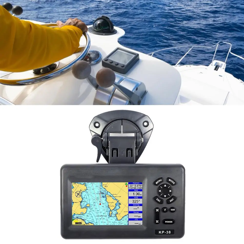
1. With the function of waypoints/ icons, there are 12,000 user waypoints, including name, sign; 3 system waypoints of MOB, start, cursor; 10 adjacent waypoints.
Specification:
Item Type: Satellite navigator
Condition: Brand new
Color: As pictures shown
Plotter:
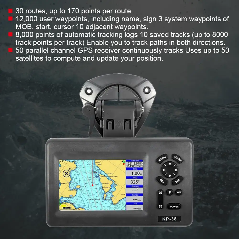
1. WAYPOINTS/ ICONS: 12,000 user waypoints, including name, sign; 3 system waypoints: MOB, start, cursor; 10 adjacent waypoints
2. ROUTES Maximum: 30 routes, up to 170 points per route
3. TRACKS: 8,000 points of automatic tracking logs; 10 saved tracks (up to 8000 track points per track). Enables you to track paths in both directions
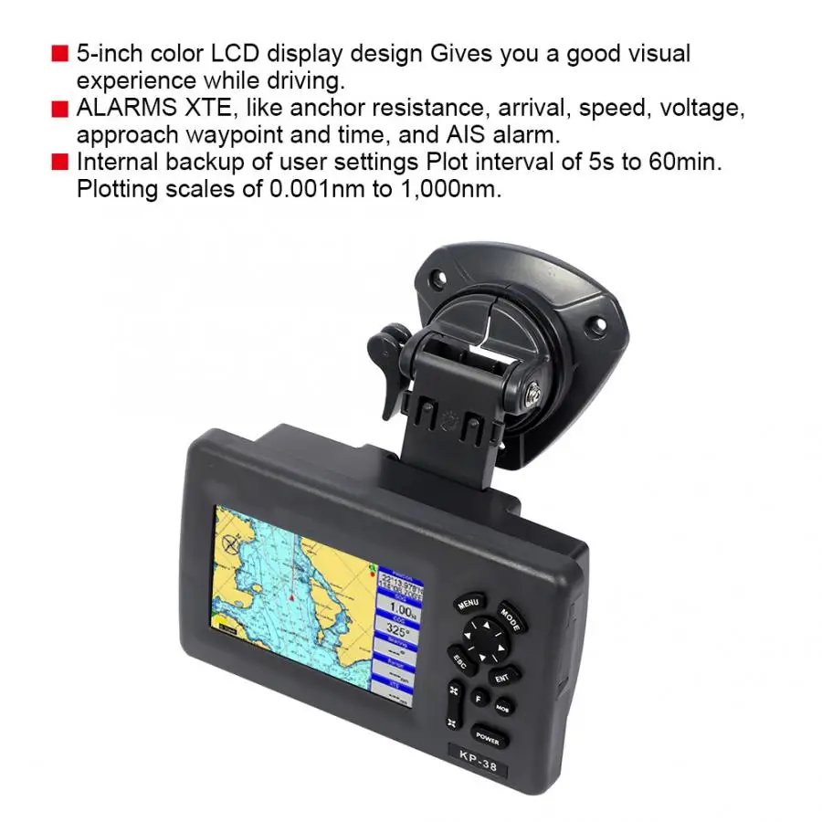
4. ALARMS XTE, anchor resistance, arrival, speed, voltage, approach waypoint and time, AIS alarm.
5. PALLETE:
Normal
Daylight exposed to sunlight
Night in dark environment
NOAA paperchart colors
6. TIDES: Tide data
7. PROJECTION: Mercator projection
8. POSITION FORMAT: Degree of minutes and UTM
9. BASEMAP: Built-in Onwa K-Chart
10. EXTERNAL MAP: Memory Cards slot for C-Map Max and ONWA K-Chart
11. USER DATA STORAGE: Internal backup of user settings
12. PLOT INTERVAL: 5s to 60min. 0.01nm to 10nm
Automatic way
13. PLOTTING SCALES: 0.001nm to 1,000nm
14. NAV DATA Inputs:
$–GGA, $–GLL,$–GSA, $–GSV,$–RMC,
$–VTG, $–ZDA, $–VWR,$–VWT,$–MWD, $–VPWOutputs:
GGA,GLL,RMC,AAM,APA,APB,BOD,
BWC, BWR,DBT,DPT,HDT,MTW,RMB,
TLL,VTG,WPL,XTE,ZDA,ZTG,ZDL,MWD,
VPW,VWR,VWT
Outputs for autopilot:
$–APB,$–BOD,$–XTE,$–APA
15. PERSPECTIVE VIEW On/off
16. CELESTIAL Sunrise/Sunset Moonrise/Moonset
POWER SUPPLY
10.5 to 35VDC, current drain<1.0A at 12V
PHYSICAL
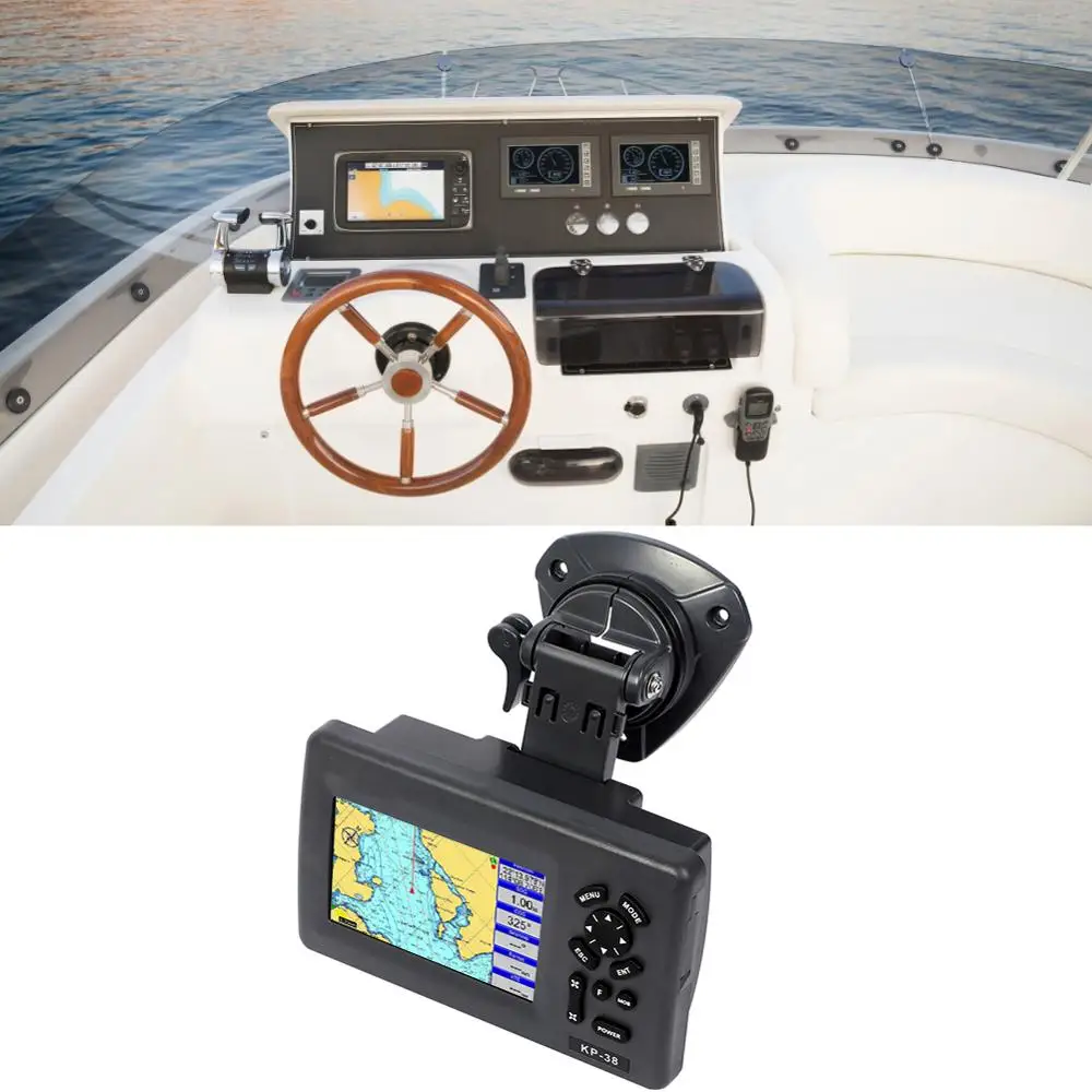
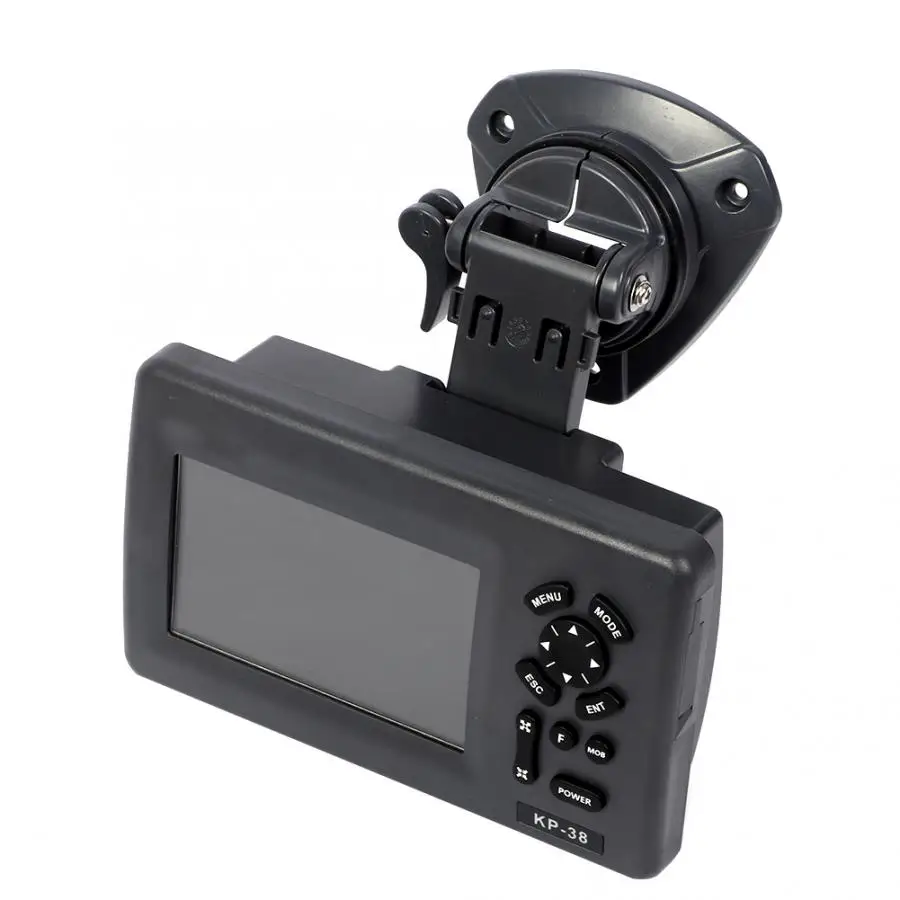
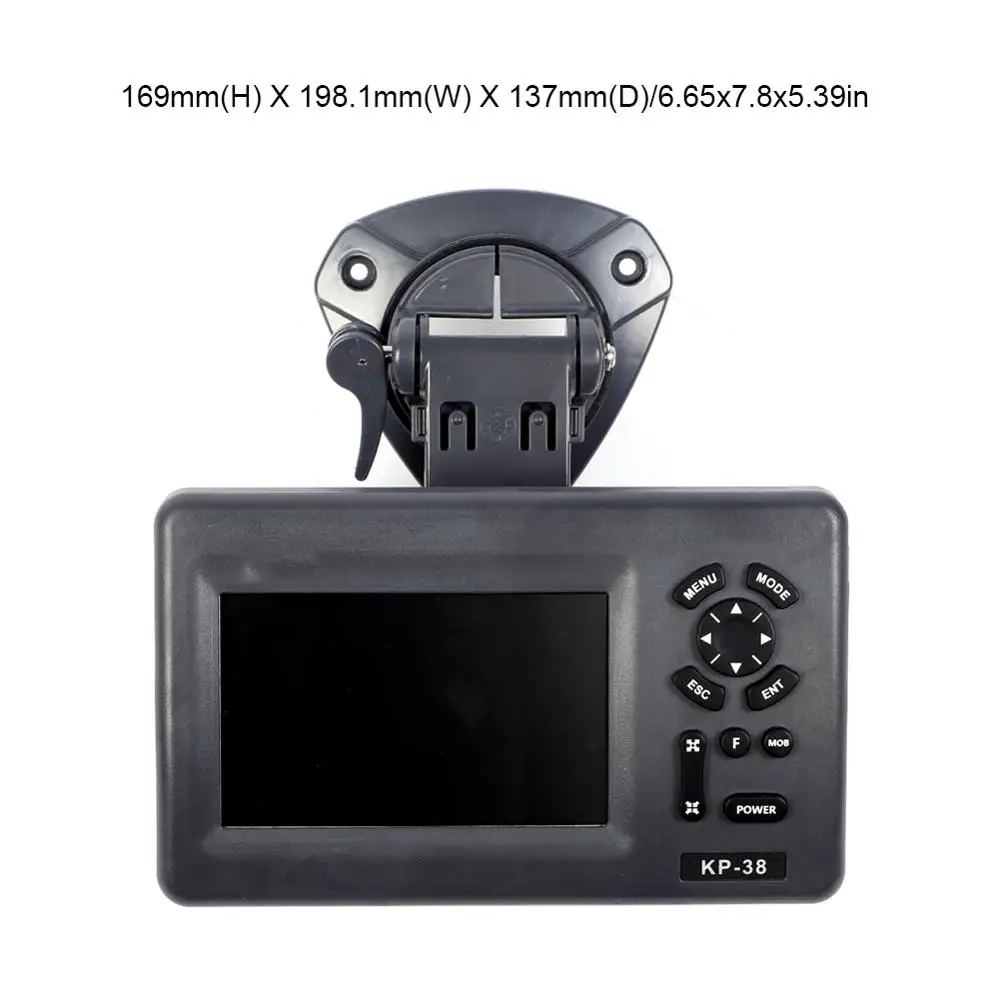
1. SIZE: Approx.169mm(H) X 198.1mm(W) X 137mm(D)/6.65x7.8x5.39in
2. WEIGHT: Approx.560g/19.75oz
3. DISPLAY: 5-inch Color TFT dayview LCD,800×480 pixels
4. INPUT & OUTPUT PORT: One opto-isolated input Port
One RS232 Output Port
5.WATERPROOFING: Display unit: IPX5
Antenna Unit: IP66
6. TEMPERATURE RANGE: Display unit: -5℃ to +55℃
AIS INTERFACE
DATA INPUT: NMEA 0183 , RS232
BAUD RATE: 38,400
GPS RECEIVER CHARACTERISTICS
RECEIVER: 50 parallel channel GPS receiver continuously tracks and uses up to 50 satellites to compute and update your position
ACQUISITION TIME: Cold start: 60 seconds average
HOT START: 45 seconds average
UPDATE RATE: 1/second or 10/second (selectable) , continuous
POSITION: 2.5 meters (95%) without S/A
VELOCITY: 0.1 Meter/sec without S/A
TIME: 100ns synchronized to GPS time
DYNAMICS Altitude: 50,000m maximum
VELOCITY: 500 m/s
ACCELERATION: 4g Maximum
DATUM WGS 84 and user define
Package List:
1 x 5inch Satellite Navigator 1 x Screen Protector 1 x GPS Antenna 1 x Power Cord 1 x Manual 2 x Fuse 3 x Screw 1 x Bracket


Смотрите так же другие товары:


